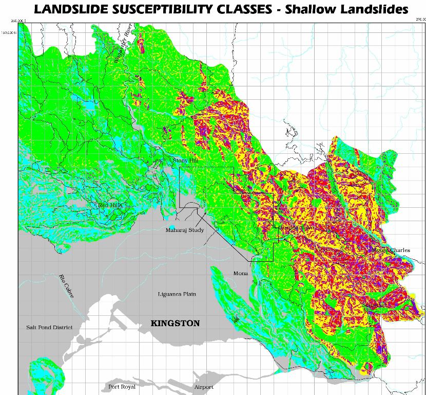
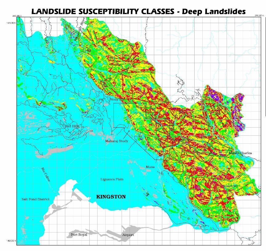
1. Two landslide susceptibility maps have been prepared for the Kingston Metropolitan Area:
(i) Shallow Landslides Susceptibility Map, and (ii) Deep Landslides Susceptibility Map.
NOTE: For a detailed description of factor analysis and susceptibility zones reference should be made to Publication no.5, Unit for Disaster Studies, UWI, Mona, Kingston 7, Jamaica .
Submarine Landslide Susceptibility on the Palisadoes and other areas on the south coast are beyond the scope of the present work. 2. The susceptibility zones shown on the maps reflect variable potential for initiating a landslide on a slope, but do not necessarily indicate how far the landslide will travel, or where the landslide debris (or debris flow) will be deposited. Additional hazards from landslide deposition may exist downslope from the high susceptibility regions shown, or at the mouths of drainage basins with highly susceptible slopes.
3. Land use planners, developers and general public may use these maps to determine areas where landslides may be a problem in site development, and/or where a report/s from geologists and geotechnical engineers should be required prior to undertaking any site development activities. These maps can not be used to determine the hazard to any individual structures/ site development. These maps should not be used as a substitute for detailed geologic/geotechnical site investigations. Slopes that are stable at the present time may be rendered unstable by natural or man-made processes. These maps show relative landslide hazard, that is, which areas are more hazardous than others. Areas of high susceptibility to landsliding generally coincide with areas where there is high incidence of landslides.
4. Many of the areas of potential slope instability may be suitable for development, even if landslides are present provided that correction/mitigation strategies are employed based on comprehensive geologic and geotechnical evaluations and advise. The geologic-geotechnical report should include an evaluation of existing ground stability, proposed changes/alteration to drainage and topography, and recommendations for remedial and/or preventive measures to improve and/or maintain slope stability. Permission to develop a site must be approved by appropriate authority. The site report/s should be available to the potential homebuyers.
5. The accompanying Landslide Susceptibility Maps for Shallow and Deep Landslides include FIVE MAPPED SUSCEPTIBILITY CLASSES based on landslide densities in each class. These classes are based on: (A) For Shallow Landslides on landslide densities for active landslides and slide zones only in 83 unique combinations of factors related to slope, Aspect, Lithology, and Slope Curvature, and (B) For Deep Landslides on landslide densities for Scarps-definite and Scarps-probable landslides only in 249 unique combinations of factors related to Slope, Aspect, Lithology, and Distance to Faults.
6. For general purpose use the range of landslide susceptibility are condensed into 4 categories:
(a) Low susceptibility, (b) Moderate susceptibility, (c) Moderate-high susceptibility and (d) High susceptibility - which incorporates the original zones of very high and high susceptibility containing identified active landslides.
LANDSLIDE SUSCEPTIBILITY CATEGORIES:
Low Susceptibility(colour code : blue): Areas for which the combination of factors is generally unlikely to adversely influence slope stability. Site development to be guided by normal planning and other building regulations.
Moderate Susceptibility (colour code-green): Areas for which the combination of factors is less likely to adversely affect the stability provided that the existing ground conditions are not radically altered to facilitate site development.. The scale and nature of proposed development should be taken into consideration.
Moderate-high Susceptibility (colour code- yellow): Areas for which the combination of factors may adversely influence slope stability. Slopes are covered with a thick blanket of weathered rock and colluvium (debris) which when disturbed are prone to landslides. Debris flows should be anticipated. Development may proceed based on geologic-geotechnical investigations and advice (See Point 4 above). The cost of investigations and remedial and/or preventive measures are likely to be high.
High Susceptibility (colour code- purple and red): Areas for which existing ground conditions are likely to create serious landslide problems. It includes areas near faults and fault scarps. In general, these areas are unsuitable for site development. The cost of carrying out standard geologic-geotechnical investigations and remedial/preventive work for slope stabilization may be very high. Therefore, it is best to avoid these slopes as far as possible except for the most essential use. A thorough ground investigation report by competent persons should be required before any site development is undertaken.