 or for guidelines |
 |
 or for guidelines |
On January 26-28, 1999 the Unit for Disasters Studies of The University of
the West Indies, Kingston, Jamaica hosted a workshop focused on issues of
landslide hazard mitigation and loss-reduction strategies. The purpose of
this workshop was to demonstrate the magnitude of landslides and related
problems in the Kingston area, their direct and indirect effects on society,
the constraints they place on current and future land use and the benefits
of landslide hazard mitigation. This workshop was the culmination of the
landslide component of the Kingston metropolitan area multi-hazard
assessment, which is funded by the USAID/OAS Caribbean Disaster Mitigation
Project (CDMP).
This workshop was the culmination of the Project Landslide Hazard Mapping for the Kingston Metropolitan Area which is a part of the Kingston Multi-hazard Assessment Project of the Caribbean Disaster Mitigation Project. The workshop was hosted by Rafi Ahmad, professor in the Department of Geography and Geology, Unit for disaster Studies, University of West Indies, Mona, Kingston, Jamaica. Approximately 45 professionals from Jamaica attended the workshop representing an array of disciplines: geology, engineering, water and transportation, disaster response, development and urban planning, and environmental management. The workshop appeared to be the first time such a group of diverse sector representatives, all of whom have some degree of implied responsibility to incorporate landslide awareness into their professional work in Jamaica, have heard from each other in an organised fashion.
The workshop's main objective was to present project results to an audience of government officials, scientists, planners, and other who are most likely to integrate landslide hazard data and awareness into development, disaster preparedness, and response in Jamaica. Second, project organisers hoped to initiate important dialogue about "where to go from here" with the new information. Although the breadth of the audience was impressive and included academics, government geoscientists, and representatives from Disaster Management agencies, land-use planning and transportation sectors, there were some key sectors underrepresented over the three days including: geotechnical consultants, the building industry, municipal government, landowner or neighbourhood associations, and the public schools. Clearly, this is a beginning and an important follow-on activity for this project will be to find ways to disseminate the information to appropriate users.
On day one, after welcomes from various project principals, we heard about the science and systematic of tropical landslides, details of the assessment strategy and GIS-based approach of KMA, and viewed the resulting landslide inventory and susceptibility maps. In the afternoon, we heard about engineering solutions to landslide mitigation from Bill Cotton, a consulting geologist from the Bay area. We then began a group exercise led by David Howell of the USGS to evaluate the state of landslide awareness and relevant data in Jamaica and began to answer thorny questions of responsibility and authority in reducing risk from landslides in Jamaica. This was a useful exercise, highlighting both the resources and the gaps in information and coordination. (An analysis of this session by Howell, Brabb and Ahmad will be published in the proceeding volume for the 9th ICFL.)
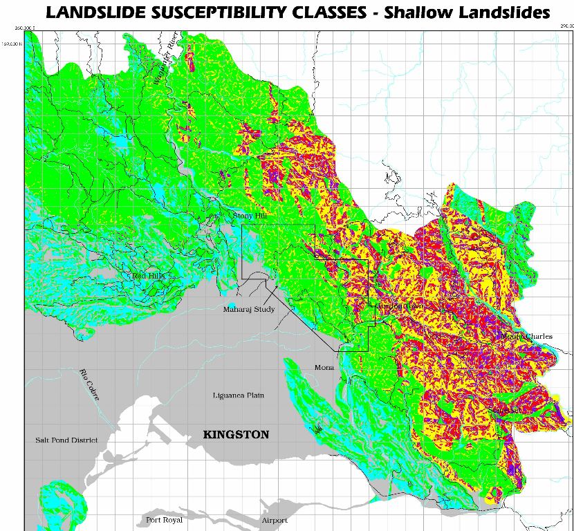
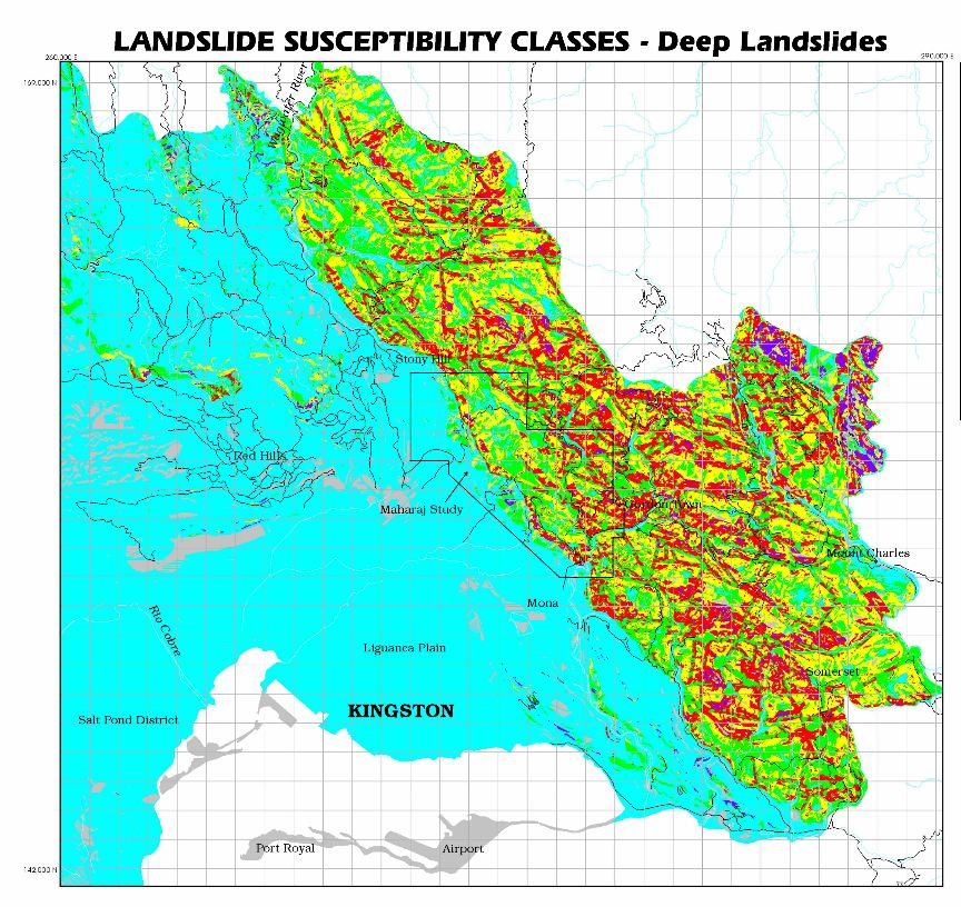
During the first section, historical landslide information and landslide susceptibility maps that were developed under the CDMP Kingston multi-hazard assessment project were presented and discussed. These maps provide a basis for understanding the variability of landslide risk across the Kingston metropolitan area. Jim McCalpin, who collaborated with Rafi Ahmad in producing these GIS maps, reflects "I had all sorts of ideas at the Jamaica Workshop for quantifying uncertainty, which was not part of my original study. Put another way, if a pixel ends up classified as High or Moderate Hazard on the final susceptibility map, what is the probability that it actually should be in that class, as opposed to being in one of the adjacent classes? The question arose because my map has isolated pixels of high hazard in areas of mainly low hazard pixels, and vice versa. So, how literally should we take the hazard ratings in such a case? One option would be to smooth the final hazard map (which has 5 or 6 categories) by running a mean (low-pass) filter over it. This deliberate degrading of the map basically covers a host of uncertainties (spatial and numerical), like how accurate the DEM is, how accurate the geologic contacts are, whether the geologic units contain internal variability that would change slide susceptibility, etc. etc. Quantifying all these uncertainties in any rigorous way would be tedious. Deliberate degradation of the final susceptibility map with one or more passes of a mean filter would be an admission that we really cannot trust these maps at the pixel scale, which in most cases is probably the safe thing to do."
The map products and reports produced by the KMA are useful in efforts to (1) spread the word about the acute landslide hazards in the Kingston area - and by association other growing parts of Jamaica's infrastructure - and (2) indicate high priority areas where more detailed, site specific work may be needed. Although resources to support continued mapping and dissemination of results in a meaningful manner is somewhat in question, I think the results to date are technically sound and form a good basis for education. OFDA and OAS and other project participants will be conducting a critical evaluation of the effectiveness of KMA and other CDMP projects this year; lessons learned may well determine if this type of activity will be replicated elsewhere in the region.
A field trip on the second day led us up into the hills behind Kingston proper to view a number of young, active landslides, debris flow source areas, sites of past damage to houses and roadways, and a rum factory. The field examples were informative and participants appeared to be hearing key and provocative information about landslide processes for the first time. The group asked numerous practical, solution-demanding questions.
Day three convened back at the hotel for more presentations on the results of susceptibility mapping and how this is or is not part of the current land-use planning process, and the relationship of landslides to watershed management. There was some spirited discussion about why high-risk building continues and who has the authority and responsibility to intervene. Also, representatives of grass-roots rural non-governmental organisations pushed hard for codification of information that is relevant and appropriate for the average farmer - someone whose livelihood depends on intensive land use and who cannot afford major geotechnical solutions or simple relocation.
One of the foreign guest at the conference was Tina Neal, is a USGS volcanologist, currently on temporary assignment as the geoscience advisor to the USAID (U.S. Agency for International Development), Office of U.S. Foreign Disaster Assistance (OFDA) in Washington, D.C. OFDA is the US government agency responsible for coordinating humanitarian relief following a disaster overseas. She wants us to know that increasingly, OFDA is attempting to initiate and support mitigation programming where preparedness, prevention and planning can make a difference in reducing risk from natural and other hazards. To that end, OFDA now employs a cadre of technical specialists in geoscience, geography, cartography, anthropology, public health, urban planning, and civil engineering whose primary responsibility is to seek opportunities to implement support mitigation efforts overseas and to provide technical support as needed.
An example of mitigation programming by OFDA is the Caribbean Disaster Mitigation Project (CDMP) funded by OFDA and implemented by the Organization of American States (OAS), Unit for Sustainable Development and the Environment. The CDMP consists of a number of pilot projects in selected Caribbean nations and it includes hazard assessments, development of disaster preparedness plans, and other mitigation activities related to seismicity, storm surge and hurricane winds, and landslides. One element of the CDMP is the Kingston Multi-Hazard Assessment (KMA) Project that has sought to address specifically the landslide hazard in the greater Kingston area. This project is coming to a close in 1999.
(Report prepared by: David Howell (USGS), Tina Neal, (USGS/OFDA), James
McCalpin, (GEO-HAZ Consulting Inc.), Steven Stichter, (OAS - Caribbean
Disaster Mitigation Project), Jerome DeGraff, (US Forest Service), and
William Cotton, (Cotton, Shires and Assoc.).
From ILRG Newsletter Vol. 13
Geological instabilities prevail over large sections of Jamaica's capital
city, Kingston which has an area of 554 km2 hosting some 57% (approximately
700,000) of islands' urban population. Kingston is located on the Holocene
gravel fan of Liguanea at the base of the faulted front of the Port Royal
Moutains. The hillslopes surrounding the fan are prone to landslides because
of particular combinations of geologic history and lithology, abundant
discontinuities due to an intense development of faults and joints along
which hydrothermal alteration and mineralization is common, tectonic setting
in a seismically active plate boundary zone, and orographic rainfall as a
result of islands' geographic location in the path of tropical storms and
hurricanes. Landslides cover approximately 19.78 km2, or 4.77% of Kingston's
mountainous terrain. Landslide damage in Kingston keeps on increasing
dramatically as the pace of urbanization intensifies on geologically
sensitive slopes. Many residential areas and infrastructure are located on
large ancient landslides. It is a common observation that most of the new
landslides occur on slopes that had previously failed. Landslide hazard in
Kingston is symptomatic of changing landuse. However, small island states,
such as Jamaica, with a limited area of some 11,000 km2, must utilize their
available land resources to meet the needs of its population inspite of the
inherent geological constraints on landuse. Management of landslide hazard,
although important, is a difficult and challenging task given the perception
of the hazard, lack of overall organizational support, and limited financial
resources.
The paper examines the landslide hazard and damage in Kingston in the context of local social and economic factors. It is suggested that a practical and cost-effective approach to landslide loss reduction must be based on communicating the fundamental, field-based geologic and structural data which control landslides to communities, government agencies and individuals affected by slope movements.
(From Rafi Ahmad, Unit for Disaster Studies, Department of Geography and Geology, The University of the West Indies, Mona, Kingston 7, Jamaica, rahmad@uwimona.edu.jm )
| first version: 19990724 benrafi, second version:19990809 rafimax, latest version:19990826 maxrafi |
|