
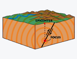
An earthquake is a sudden movement of the earth's crust accompanied by the generation of seismic waves that travel outwards from the source. (See figure on right) The sudden ground motion or vibration is produced by a rapid release of stored up energy. The movement take place along fault-planes in the earth's crust. It is the seismic waves that produce the gound motion which people feel and call an earthquake. However, there are more earthquakes recorded by instruments than those that are felt by people. Strong seismic waves can cause great local damage and can travel large distances. Even weaker seismic waves can travel far but are most likely to be detected by sensitive scientific instruments and not by people.
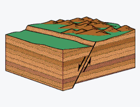
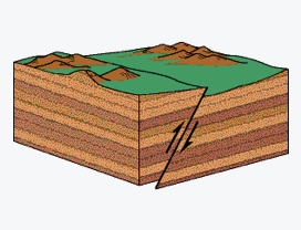
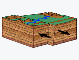
A fault is a fracture in the earth, along which one side has moved in relation to the other. Faults are usually classified according to the direction of motion of the two rocky blocks on either side of the fault being observed: mainly normal, reverse and strike-slip faults. (See three simplified figures below). However in reality , it is much more common to have some combination of fault movements occurring together.
The energy released during the sudden ground motion comes from a build up over long periods of time, as a result of tectonic forces within the earth. Plate boundaries are made up of many faults. The edges of these faults are not smooth like a table top but are rough. Imagine the difficulty your friend would have in pulling your hands apart when you interlace your fingers, as opposed to you just pressing flat palms together. Likewise, these fault planes, most times, are stuck together. While the edges of faults are stuck together, and the rest of the block is moving, the energy that would normally cause the blocks to slide past one another is being stored up. When the force of the moving blocks finally overcomes the friction of the jagged edges of the fault, they no longer stick together and all stored energy is released.
Earthquakes are caused by a build-up and sudden release of strain in the earth's crust. The strain normally accumulates slowly and is released when it exceeds the friction on the fault-plane.
Jamaica, like many other landmasses, has a number of faults. One of the Earthquake Unit's functions is to determine which faults are active and may produce damaging earthquakes in the future.
A seismometer is the scientific instrument used to detect earthquakes. Signals received from seismometers are recorded and this allows scientists to calculate the size (amount of energy released) of an earthquake, that is, its magnitude. Usually the data is received from several seismometers all located at varying distances from the source of the earthquake.
The first magnitude scale was devised by Charles Richter in 1935. He used the logarithmic scale (which scales numbers by a factor of 10) to accomodate the wide range of ground motions which earthquakes can cause, and this has persisted to the present. Scales today are based on various aspects of seismograms (The trace of seismic waves in time recorded on paper or digitally ) as told by the following names: body-wave magnitude, surface-wave magnitude, duration magnitude, moment magnitude. The Earthquake Unit uses the latter two scales for magnitude. Moment magnitude is the most true indication of the size of an earthquake because it is based on the amount of movement on the fault.
Another way of 'measuring' earthquakes is the intensity which describes the amount of shaking. It is the observed effects of an earthquake over a limited geographical area. Intensity scales assign whole numbers usually from I to XII (always written in roman numerals) to describe these observed levels of shaking. An intensity of 1 means the earthquake was not felt, while 12 means absolute and total destruction. In Jamaica we formerly used the Modified Mercalli Scale (MMS - 1956 version). Now we use the European Macroseismic Scale (EMS - 1998) which has been developed and tested over a period of years by a working group of the European Seismological Commission. The EMS makes the imprecise and subjective nature of assigning intensities more robust and straightforward with regard to earthquake effects on humans, objects and buildings. Our earthquake reporting form is based on the EMS.
Intensity information can be compiled and use to create intensity maps. Intensity maps give us a visual indication of where the strongest shaking was felt during an earthquake and directs us where to look for possible signs of fault movement.
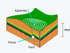
The place on the earth's surface vertically above the origin of the earthquake and is identified by geographic coordinates. Where the earthquake began is called the focus of hypocentre. The focus is the spot where the rock ruptures.
In Jamaica, the hypocentre is typically between 4 and 20 kilometres below the surface.
The Richter Scale is not an actual instrument. It is a measure of the amplitude of seismic waves and is related to the amount of energy released. This can be estimated from the recordings of an earthquake on a seismograph. The scale is logarithmic, which means that a magnitude 6 earthquake has 10 times the amplitude of ground motion as a magnitude 5, and a magnitude 7, 100 times that of a magnitude 5 and a magnitude 8.0 is 1,000 times greater.
Earthquakes cannot be prevented but the effects of earthquakes can be reduced if houses are properly designed and constructed in keeping with the National building codes and people follow earthquake safety tips recommended by the Office of Disaster Preparedness and Emergency Management (ODPEM).
Seismologists: 'seismos' from the Greek meaning earthquakes, and 'ologist' meaning a person who studies (something). A seismologist is a person who studies earthquakes and the mechanics of the earth.
In predicting an earthquake the seismologist must give the place, time and size of the event. The factors controlling these events are numerous and are not directly observable. Hence it is not possible at this time to predict earthquakes.
Earthquakes are not seasonal and not related to weather (rain, strong wind , hot or cold days) instead an earthquake is the result of geological processes occurring within the earth and can occur at any time.