
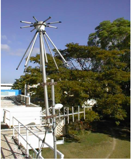
The Jamaica Seismograph Network (JSN) consists of thirteen broadband seismograph stations (pictured above) used for the continuous monitoring of seismic activity. The data from this network is used to determine magnitude and location of earthquakes in the Unit’s earthquake database.
Along with the broadband seismographs are accelerograph sensors which record significant ground motion in their immediate vicinity and are triggered by local earthquakes of magnitude 4 and higher. The JSN accelerographs, along other such sensors installed at some key institutions around the island, comprise the Jamaica Strong Motion Accelerograph Network (JSMAN). Accelerograph data is used to delimit strong ground shaking, and thereby determine areas with a high potential for damage.
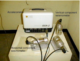
Three seismometers (sensors) attached to accelerometer
| Station Code | Station Name | Elevation (meters) |
|---|---|---|
| BBJ | Bamboo, St. Ann | 760 |
| BNJ | Bonny Gate, St. Mary | 490 |
| CMJ | Castle Mountain, Portland | 390 |
| CVJ | Pike/Coleyville, Manchester | 990 |
| GWJ | Greenwich, St. Andrew | 1170 |
| HOJ | UWI Mona, St. Andrew | 230 |
|
NEJ |
Near Negril, Westmoreland |
200 |
| MBJ | Montego Bay, St. James | 510 |
| MCJ | Munro College, St. Elizabeth | 660 |
| PCJ | Portland Cottage, Clarendon | 200 |
|
STH |
Stony Hill, St. Andrew |
500 |
| MTECB | Mount Edgecombe, Westmoreland | 166 |
| YHJ | Yallahs, St. Thomas | 600 |
Our 7 faculties and 12 professional schools offer more than 200 programmes to some 18,000 graduate, undergraduate and continuing studies students.
The UWI, Mona ranks first in Jamaica among accredited tertiary-level programmes. In 2012, the University was again one of Jamaica’s Top 100 Employers.
© Copyright 2014-2026 | Disclaimer | Privacy Statement