
Jamaica’s recorded history is rife with incidences of felt earthquakes. The famous Port Royal earthquake of June 7, 1692 was perhaps our largest and most damaging natural disaster. Although it was felt island-wide, the most extensive loss of life occurred at Port Royal, where a portion of the town sank into the sea. At least 2,000 persons died as a result of an outbreak of yellow fever, which developed after the quake. (Read more on the 1692 Earthquake here and here.)
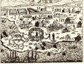
Artist's impression of 1692 Earthquake. Illustrated is the liquefaction and ground failure as the earth opens up to swallow the unfortunate residents.
The Great Kingston Quake of 1907 occurred January 14 of that year. Of the 48,000 people living in Kingston at the time, over 1,000 perished, mostly in the fires following the shocks (main and after-shocks). The aftershocks continued for the rest of the year. Some 9,000 people were left homeless throughout the island. Building damage for that event was estimated at two million pounds (approximately 308 million pounds today). (Read more on the 1907 Earthquake here.)
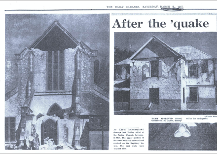
The March 1, 1957 event affected mostly Western Jamaica. The most damages were recorded in the parish of St. James, especially for its infrastructure such as buildings, bridges and roads. This event resulted in three (3) deaths and three associated fires. A full list of damaging earthquakes can be seen below.
Monitoring for earthquakes in Jamaica began with the weather service in the late 19th century. In the early 20th century, the Jesuits Association also established seismograph stations on the island. However, it was not until the early 1960s that the first modern seismograph station was installed at Hope Gardens, Geological Survey Division. In 1963, that station was moved to the Mona Campus of the University of the West Indies, from where the growth into the Jamaica Seismograph Network began. In the 1970s, the number of stations increased to three and this enabled details of epicentres and focal depths of earthquakes to be determined. Thus, the database of felt earthquakes extends back to the 17th century, while that for located events is only about 30 years long.
| Date | Places Affected | Maximum Intensity |
|---|---|---|
| March 01, 1667 | - | VIII |
| June 07,1692 | Port Royal, Kingston, Vere Plains; felt strongly islandwide | X |
| March 01, 1688 | Port Royal | VII |
| September 03, 1771 | Port Royal, Kingston | VII |
| November 11, 1812 | Kingston | VIII |
| April 10, 1824 | Kingston; Spanish Town, St. Catherine; Old Harbour, St. Catherine | VII |
| November 05, 1839 | Montego Bay, St. James | VII |
| January 14, 1907 | Port Royal, Kingston | IX |
| August 03, 1914 | Eastern Jamaica | VII |
| July 15, 1943 | St. Elizabeth | VII |
| March 01, 1957 | Montego Bay, St. James; felt islandwide | VIII |
| January 13, 1993 | Kingston and St. Andrew; felt islandwide | VII |
| June 12, 2005 | Central Jamaica - felt strongest at Aenon Town and Top Alston in Clarendon; Silent Hill, Manchester; Wait-A-Bit and Lemon Walk, Trelawny | VII |
| January 28, 2020 | Islandwide and Regional (The Cayman Islands and Cuba) | VII |
Our 7 faculties and 12 professional schools offer more than 200 programmes to some 18,000 graduate, undergraduate and continuing studies students.
The UWI, Mona ranks first in Jamaica among accredited tertiary-level programmes. In 2012, the University was again one of Jamaica’s Top 100 Employers.
© Copyright 2014-2026 | Disclaimer | Privacy Statement